A Rainy Walk Along a Canal: Reading the Edges
A rainy canal walk reveals how towpath, water and adjoining ground meet, with a simple morning route for noticing runoff, crossings and changing surfaces.
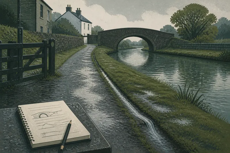
Rain beads on the towpath beside a canal, then runs into a shallow groove at the path’s edge. On a rainy canal walk, following that water from path to bank and into the adjoining ground gives the morning a clear purpose: notice how each surface directs or holds it.
Choose a public stretch with a recognisable bridge or bend as a turning point. Plan a two-hour out-and-back walk, allowing about twenty minutes to reach the turning point and return, with three brief observation stops along the way. These are planning estimates, not fixed timings; shorten the outing if rain, footing or visibility makes the route uncomfortable. Check local access information before leaving, since towpaths can close or pass beside private or working land.
Choose a route with a crossing and changing ground
A useful stretch has a crossing, such as a bridge, and at least one change in its surroundings: houses giving way to open ground, a drain meeting the canal, or a stone edge changing to grass. These features let you compare how the waterway sits within the settlement without needing to cover a long distance.
Mark a start, a turning point and three places to pause on a local map. For example, choose the towpath entrance, a bridge, and a bend near a visible drain. Keep each stop on the public path. Do not plan to climb a bank, cross a lock or approach water-control equipment.
Wear footwear with a tread suited to wet paths. A small notebook and pencil are enough for notes; a phone map can help with orientation. Check access notices before setting out, and leave the walk for another day if the route is closed or conditions are poor.
Use three timed pauses to give the morning a shape
At the starting point, spend a few minutes looking at the towpath surface and the nearest bank. Walk towards the crossing at an easy pace, then pause there to compare the canal’s two sides and the ground above them. Continue to the turning point, stop once more, and return along the same path. The exact pace depends on conditions; the purpose is to repeat the same observations, not to meet a timetable.
At each pause, note three things: the path surface, the water’s edge and the adjoining ground. Describe what you can see in plain terms, such as “gravel path, stone bank, low grassy strip”. This repeated format makes contrasts easy to recall without turning an observation into a claim about the canal’s past.
If rain becomes heavy, visibility drops, or the path feels slippery, turn back or end the walk. Do not stop where passing traffic comes close, lean over the water or step onto an unstable bank. If a public shelter is nearby and safely accessible, wait there; otherwise head back by the route you know.
Read runoff from the path to the bank
Look for where rain collects and where it flows away. A dip beside a compacted path may hold water, while a groove or drain may carry it towards the canal. Compare the wet patch with the slope around it: standing water on its own does not show that a regular drainage channel is present.
Notice how the towpath meets the bank. It might meet a low retaining wall, a sloping grassy edge, a cut face or a strip of stones. These are visible differences in the canal’s edge. They can prompt questions about how the path and bank were maintained, but appearance alone cannot date a repair or identify who carried it out.
Keep clear of outlets and moving water. A pipe or narrow channel may show where runoff enters the canal, but the area around it can be slick. Record the direction of flow from the path rather than approaching the opening.
Compare bridges, boundaries and nearby buildings
At a bridge, note what crosses the canal: a road, railway or footway. Look at how the approaches meet the towpath. A gate, a change in paving or a path that shifts banks tells you about present access. A bridge’s surface may include later repairs, so its visible appearance alone is not a reliable guide to its age.
Look beyond the towpath for walls, fences, hedges, gardens or open verges. Note where each boundary runs parallel to the canal and where it turns towards a lane or building. If a wall has an opening beside a hard-surfaced yard, describe that alignment; it may suggest a physical connection, but it does not identify what was moved through it or when.
Imagine you start at a public towpath entrance with a notebook and a map marked for a bridge and a nearby bend. At the entrance you record a firm gravel path and a grassy bank; at the bridge you note paving that narrows beneath the span; at the bend you see a shallow channel carrying rain towards the canal. You return along the same path when the rain strengthens. Your notes show a contrast between the firm entrance, constrained crossing and visible runoff at the bend, while leaving the channel’s history unresolved.
What can a rainy canal walk tell you?
Why does water gather beside the towpath?
The path may meet a low patch, or rain may run down from higher ground. Compare the wet area with the visible slope and look for a groove or drain before describing it as a route for runoff.
Can the bank show how the canal was maintained?
A change from stone to grass shows a change in the visible bank surface. It may prompt a question about repair or alteration, but the walk alone cannot establish when that change happened or who did the work.
What can a canal-side wall tell you?
A wall may divide the towpath from a property, protect the bank or mark the edge of a yard. Note where it begins and ends and whether openings align with nearby paths, without assigning a purpose based on appearance alone.
Is light rain a suitable time to walk?
Light rain can make runoff and surface changes easier to see. If the path is flooded, slippery or hard to see, choose another day or a safer, accessible stretch.
Record observations that remain useful after the walk
At each stop, write a short description of the path, bank and adjoining land. A rough sketch needs only three lines for those features, with a bridge, drain or change in surface marked where it appears. Add a direction arrow for visible runoff. These notes preserve what you saw without treating a temporary wet patch as a permanent feature.
Use this quick check at each stop:
- Check whether the towpath is firm underfoot; if it is, continue cautiously, but if it is slick or soft, turn back or choose a safer route.
- Check whether water is standing in a dip; if a visible groove leads into it, note the groove, but if there is no channel, record only a wet patch.
- Check whether a bank has a visible wall or stone facing; if so, describe its material, but if vegetation hides it, mark the edge as obscured rather than guessing.
- Check whether runoff appears to enter the canal; if a channel is visible from the path, note its direction, but if the source is unclear, leave its origin unresolved.
- Check whether the towpath continues under or beyond a crossing; if it does, follow the public route, but if access is gated or unclear, turn back and check official access information later.
- Check whether the adjoining boundary has an opening aligned with a lane or yard; if it does, note the alignment, but if there is no clear opening, do not infer a connection.
It is not worth chasing every puddle or photographing each dark mark on a wall. Rain and shade can alter how surfaces look, and a few clear contrasts are easier to compare later than a crowded set of images.
Afterwards, compare your sketch with a local map or a publicly available historic map if one is convenient. Note where roads, buildings and watercourses meet, while allowing for changes between the map and the present landscape. For questions about ownership or access, ask the relevant local authority or canal organisation rather than relying on appearances.
A rainy canal walk is easiest to interpret when you keep the route short, repeat the same observations and stop when conditions change. On your next rainy canal walk, follow one visible trickle from path to edge, then note where it goes—and where your view stops.